Home
Issues
Aims and Scope
Open Access
Editorial Board
Indexing
Why publish with us
Contact us
Instructions to authors (PDF)
Manuscript Types
Manuscript Formatting
How to submit
Preprints
Special Publications & Reprints
Authorship & COI
Principles of Transparency Checklist
Data Policies
Publication Ethics and Publication Malpractice Statement
Implementing section - 6b of Cigarettes and Other Tobacco Products Act 2004, prohibiting the sale around educational institutions using technology based software - safe zone
1
Indian Institute of Sports Medicine, India
2
Cancer Institute, Resource Center for Tobacco Control, India
3
VAYAS Technology Solutions, India
Publication date: 2018-03-01
Tob. Induc. Dis. 2018;16(Suppl 1):A300
KEYWORDS
TOPICS
ABSTRACT
Background and challenges to implementation:
Section 6b of Cigarettes and Other Tobacco Products Act (COTPA)-2004 and Article 16 of Framework Convention on Tobacco Control (FCTC) insists on restricting the access and availability of tobacco products to children as one of the supply reduction measures. Several countries have taken initiatives restricting the sale of tobacco products near Educational Institutions (EIs) and in India it is prohibited around 100 meter radius. However, the implementation has become a major challenge as it is difficult to map the distance between EIs and tobacco outlets, and to prove the shop keepers that they are evading the law. To address this issue, an android based application called Safe Zone is designed.
Intervention or response:
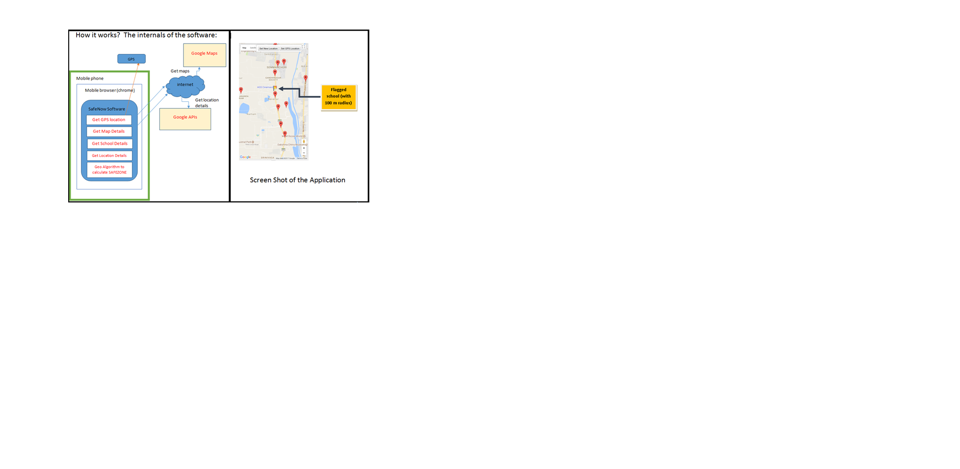
Safe Zone is a Software tool that helps to identify tobacco outlets in and around EI. The technology used was Google MAP API, Google Maps, HTML5 / CSS3 / Java Script, GPS - Global Positioning System and GPRS - Data connection, Geo-coordinates algorithm. The details of the software are given as Figure 1.
Results and lessons learnt:
This software gets your current GPS location and finds all EIs within 100 meter radius nearby and flags us along with the distance. It can show us the precise DISPLACEMENT between given shop and given EI locations. This software works in almost all smart phones that have GPS and GPRS - data connection.

[The internals of the software]
Conclusions and key recommendations:
This can be customized and used in any country based on their respective country law. It will help the Social activists, Government officials and Law Enforcement officers, who wants to enforce the Law of the Land in creating safe zone to take evidence based actions to curtail the sale of tobacco in the EI zones and General Public who wants to check whether their kid's school/ home is located in a tobacco free zone or not.
Section 6b of Cigarettes and Other Tobacco Products Act (COTPA)-2004 and Article 16 of Framework Convention on Tobacco Control (FCTC) insists on restricting the access and availability of tobacco products to children as one of the supply reduction measures. Several countries have taken initiatives restricting the sale of tobacco products near Educational Institutions (EIs) and in India it is prohibited around 100 meter radius. However, the implementation has become a major challenge as it is difficult to map the distance between EIs and tobacco outlets, and to prove the shop keepers that they are evading the law. To address this issue, an android based application called Safe Zone is designed.
Intervention or response:
Safe Zone is a Software tool that helps to identify tobacco outlets in and around EI. The technology used was Google MAP API, Google Maps, HTML5 / CSS3 / Java Script, GPS - Global Positioning System and GPRS - Data connection, Geo-coordinates algorithm. The details of the software are given as Figure 1.
Results and lessons learnt:
This software gets your current GPS location and finds all EIs within 100 meter radius nearby and flags us along with the distance. It can show us the precise DISPLACEMENT between given shop and given EI locations. This software works in almost all smart phones that have GPS and GPRS - data connection.

[The internals of the software]
Conclusions and key recommendations:
This can be customized and used in any country based on their respective country law. It will help the Social activists, Government officials and Law Enforcement officers, who wants to enforce the Law of the Land in creating safe zone to take evidence based actions to curtail the sale of tobacco in the EI zones and General Public who wants to check whether their kid's school/ home is located in a tobacco free zone or not.
Share
RELATED ARTICLE
We process personal data collected when visiting the website. The function of obtaining information about users and their behavior is carried out by voluntarily entered information in forms and saving cookies in end devices. Data, including cookies, are used to provide services, improve the user experience and to analyze the traffic in accordance with the Privacy policy. Data are also collected and processed by Google Analytics tool (more).
You can change cookies settings in your browser. Restricted use of cookies in the browser configuration may affect some functionalities of the website.
You can change cookies settings in your browser. Restricted use of cookies in the browser configuration may affect some functionalities of the website.

